• Skip to main content
  • Skip to after header navigation
  • Skip to site footer
  • Facebook
  • Instagram
  • LinkedIn
San Dieguito River Park

San Dieguito River Park

Preserving and interpreting the natural and cultural resources of the San Dieguito River Valley

  • Home
  • About Us
    • Mission & Goals
    • History of SDRP
    • Partners
    • JPA Board of Directors
    • Citizens Advisory Committee
    • Park Staff
    • Accomplishments by Year
    • Documents and Archives
    • FAQs
    • Contact Us
  • Trails
    • Trail Maps
    • General Park Rules
    • Pet Safety: Dogs
    • Geocaching Policy
    • Regional Trails Network
    • Coast to Crest Trail Status
  • Events
    • Calendar of Events
    • Event Planning
    • Schedule a Field Trip
    • Watershed Explorer Program
  • Get Involved
    • Volunteer Opportunities
    • Scout Projects
    • Research Opportunities
  • Explore
    • Lagoon Bird Surveys
    • Interpretive Programs
    • What’s Happening at SDRP
    • Videos
  • Sikes Adobe
    • About Sikes Adobe
    • History of Sikes
    • Volunteer at Sikes
    • Friends of Sikes Adobe
    • Plan a Celebration
  • Projects
    • Park Projects
    • Request for Proposals
  • Donate
    • Monetary Gifts
    • Boardwalk Planks
    • Membership
    • Other Ways of Giving

Watershed Relief Map for Volcan Mountain’s Watershed Year

Home - News and Announcements - Watershed Relief Map for Volcan Mountain’s Watershed Year

September 17, 2015
Posted by: Shawna Anderson
Featured in the photo from left to right are: Kathleen Beck, Bill Porter, Jim Lydick, and David Mosier. Photo by Jeff Holt

Our partner on the crest end of the park, Volcan Mountain Foundation, has some exciting news to share in the following guest blog post by VMF Board Member Jeff Holt.

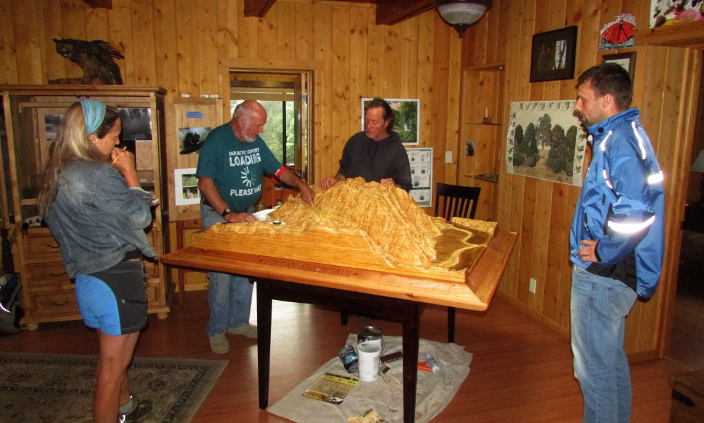
Over a year ago, Kathleen Beck, Education Coordinator for the Volcan Mountain Foundation (VMF), envisioned a watershed relief map that could help teach visitors about Volcan Mountain’s vital watershed sources, and give them a hands-on experience on how watersheds function. She presented the idea for the 3D representation to a once local artist, Eleanor Warner. The artist made up a plan that was presented to the VMF Board of Directors that said, “Go find the money.” Over $6,000 was raised over the next year; meanwhile, Eleanor and wood working artist, Matt Johnson, started the project in earnest.

There were key contributions to the project from: the Michael & Paula Rantz Foundation, the Willis & Jane Fletcher Family Fund I at The San Diego Foundation, and the Community United Methodist Church in Julian, along with proceeds from VMF’s Julian Film Festival. VMF Advisory Board member, Diane Coombs was a major champion of the project, which will be an integral part of VMF’s partnership in the San Dieguito River Watershed Explorers program. The program provides a much-needed opportunity for underserved students to get outdoors while learning about the importance of our region’s watersheds.

As part of the hands-on watershed lesson, visitors will be able to spray ‘rain’ over the very detailed relief map and see what happens as the water flows down on its way to the Pacific Ocean and the Salton Sea. The map is part of the interpretive displays at VMF’s Volcan Mountain Nature Center located at the end of Farmer Road at the base of Volcan Mountain. Still to come is a permanent stand for the map that will be created by metal artisan Bill Porter. If you would like to arrange a visit, please contact Nicole at the VMF office (760-765-2300), or you may contact Kathleen directly (760-518-3273).

For more information about Volcan Mountain and the Volcan Mountain Foundation visit www.volcanmt.org.Page opens in new window.

Media Contact:
Colleen Bradley
Colleen@VolcanMt.org
Post Office Box 1625
Julian, CA 92036
(760)765-2300

###

Featured in the photo from left to right are: Kathleen Beck, Bill Porter, Jim Lydick, and David Mosier. Photo by Jeff Holt


Category: News and Announcements
Tag: Volcan Mountain, watershed


Previous Post:SDRP Insect Survey Completes First Year of Data Collection
Next Post:AmeriCorps NCCC Service Project
San Dieguito River Park, San Diego, CA

Stay Connected with the River Park

SUBSCRIBE TO OUR NEWSLETTER


This form is protected by reCAPTCHA and the Google Privacy Policy and Terms of Service apply.

MAKE A DONATION

Make monetary donations to the River Park via our secure PayPal page. Funds can be specified for any of our programs, or be left undesignated to be used as needed. Click on the DONATE button below to make a monetary donation NOW! All donations are tax deductible.

ATTEND AN EVENT

The San Dieguito River Park hosts a variety of events throughout the year, from volunteer activities to bird walks. Check out what’s coming up on our calendar!

VIEW EVENTS CALENDAR
Other ways of giving to SDRP

See more ways that you can help the River Park realize its goals

Partnerships

About Our Partners & Member Agencies

SDRP

  • Park Staff
  • Employment
  • Event Planning
  • What’s Happening at SDRP
  • Environmental Hazards
  • Documents
  • Plants of the San Dieguito River Valley PDF opens in a new window.
  • FAQs

Trails

  • Trail Maps
  • Regional Trails Network
  • Coast to Crest Trail Status
  • Google Map: trails, parking & points of interest Page opens in new window.
  • San Dieguito Lagoon Field Guides Page opens in new window.

RULES

  • General Park Rules
  • Pet Safety
  • Geocaching Policy

CONTACT

San Dieguito River Park
18372 Sycamore Creek Road, Escondido, CA 92025

Tel: 1-858-674-2270
Fax: 1-858-674-2280
Email: sdrp@sdrp.org


  • Facebook
  • Instagram
  • LinkedIn
Back to Top ↑

Copyright © 1997-2025 San Dieguito River Park · All Rights Reserved · Privacy